The Singing River
In native American Legend, the Manatee River, dividing line between the Calusa and Timicuan peoples, is known as the “Singing River” because of the most beautiful and lovely music it mysteriously made on certain moons.
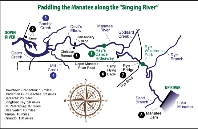
The river begins near the Four Corners at 136 feet above sea level, the highest point in Manatee County. It flows south, then west through Lake Manatee to Tampa Bay, a total of 46 miles. The 11 mile section from the Manatee Dam to Gamble Creek, including The Upper Manatee Canoe Trail, offers excellent paddling because of the ample depth of water, slow-moving stream and forested banks that can provide shade from the sun and windbreaks on breezy days.
Make Ray's Canoe Hideaway your starting point for exploring the river's scenery, wildlife and history.
1. Ray's Canoe Hideaway is at the center of the Florida State Upper Manatee River Canoe Trail from Mill Creek to Rye Bridge. The river here offers easy flat water paddling. Go up or down river from Ray's, then paddle back. The depth, speed and direction of the current can vary with the tide and the rate of run-off, but is usually under 2 mph.
Approximate one-way distances and paddling times:
UP RIVER (east, to right off ramp)
![]() Camp Flying Eagle...1.3m, 45min
Camp Flying Eagle...1.3m, 45min
![]() Rye Bridge...2.6m, lhr 30min
Rye Bridge...2.6m, lhr 30min
![]() Manatee Dam...5.5m, 3hr
Manatee Dam...5.5m, 3hr
This way you'll cruise past beaches and sandbars, ideal for a picnic or swim. Enjoy the lush subtropical vegetation on either bank.
DOWN RIVER (west, to left off ramp)
![]() Christian Retreat...1.4m, 50min
Christian Retreat...1.4m, 50min
![]() Devil's Elbow...1.8m, 60min
Devil's Elbow...1.8m, 60min
![]() Mill Creek...3.5m, 2hr
Mill Creek...3.5m, 2hr
Downstream the river widens. It is lined with savannah and saltmarsh rich with birds.
2. Fort Hamer, named after a brigadier general of the Florida Volunteers, was built in 1849 on the south shore across from the present public boat ramp, as one of several fortifications around Tampa Bay. The garrison of 165 men stood down in 1850 when the suspected Seminole uprising never came about. However the fort again saw brief service in the third Seminole war of 1656.
3. Gamble Creek is 35 miles in length. As Goddard settled at its mouth in 1850. The creek is named for his former employer, the planter, Robert Gamble. The original homestead was burned during the seminole war of 1856. A dock here shipped crops to Tampa.
4. Mill Creek got its name in the 1860s when settler Andrew Pope was caught after heavy rain in what he described as the "milling water" of the creek. He became entangled in vines and thus was saved from being swept away. After the Manatee-Arcadia railroad was built in i915 several saw mills and turpentine stills were sited along the banks.
5. Christian Retreat, began 50 years ago as a campground by Gerald Durstine, a Mennonite missionary to the area, is now a 11O-acre church, residential and vacation complex. The property includes the site of "Maydell", a grand two-story home built in 1917 east of Mill Creek by Albert Huyler. He was the owner of the oak Knoll Grapefruit Company and sponsor of Huyler Boulevard, the first road linking communities to the east, part of which became Upper Manatee River Road. Across the river is an abandoned "native" village where missionaries once trained to prepare for missions to Africa.
6. Camp Flying Eagle provides camping and recreation for hundreds of boy scouts and other children, many of them from outside Florida. It's also the site of the “Singing River Days” an annual gathering of buckskin-clad outdoors enthusiasts.
7. Rye, site of the first bridge built across the Manatee in 188O, takes its name from Erasmus Rye, a Virginia settler of Scottish descent. The community no longer exists, but from 1875 to the early 19OOs, Rye was a thriving logging and farming settlement of 75 families at the head of navigation on the river. Sam Mitchell, a Tampa merchant who moved to Rye, laid out a subdivision of five north-south streets and four east-west avenues called Mitchellville. The name changed back to Rye in 1884 when the Post office opened and it was ruled there was already another Florida Post office called Mitchellville. By 1929 the community was in serious decline and the Post office closed. The last homes were bought by Manatee County in 1984 and moved away because of the risk of flooding.
8. Manatee Dam was built in 1965 to create a reservoir for Manatee County and the city of Sarasota. It is 50 feet high, 450O feet long and over 30 feet wide at its crown. The river flowing into the narrow ravine to the east of the dam area us 123 square miles and has filled a lake that is 9 miles long and about 40 feet above sea level. The spillway below the dam is popular with fishermen and a reputed area for finding petrified bone fossils and sharks' teeth.